You are using an out of date browser. It may not display this or other websites correctly.
You should upgrade or use an alternative browser.
You should upgrade or use an alternative browser.
East Tennessee Weather II
- Thread starter rocktopper16
- Start date
headhunter15
Well-Known Member
- Joined
- Mar 5, 2010
- Messages
- 9,203
- Likes
- 33,375
Matt2496
Well-Known Member
- Joined
- Dec 2, 2016
- Messages
- 14,471
- Likes
- 23,317
headhunter15
Well-Known Member
- Joined
- Mar 5, 2010
- Messages
- 9,203
- Likes
- 33,375
MetVol
🌪️⚡❄️☀️🎣
- Joined
- Dec 8, 2020
- Messages
- 240
- Likes
- 708
I know there's a chance of really bad weather but 2011 bad? That was a once in a lifetime kind of event.
It's an active pattern, but it's a lot different than 2011.
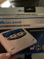
Honestly don't see much of a severe risk across East Tennessee Wednesday night, but people should at least monitor the situation. Still a good idea to have multiple ways of receiving warnings (weather radio, WEA, etc) and ensure redundancy. For this event, the occlusion process of the cyclone will limit the northward movement of the warm front. This should keep most of the severe risk across MS, AL and also western TN along the warm front and on the warm sector side of the front.
headhunter15
Well-Known Member
- Joined
- Mar 5, 2010
- Messages
- 9,203
- Likes
- 33,375
rocktopper16
Spread sunshine, Not shade.
- Joined
- Jan 8, 2012
- Messages
- 12,197
- Likes
- 12,507
headhunter15
Well-Known Member
- Joined
- Mar 5, 2010
- Messages
- 9,203
- Likes
- 33,375
headhunter15
Well-Known Member
- Joined
- Mar 5, 2010
- Messages
- 9,203
- Likes
- 33,375
MetVol
🌪️⚡❄️☀️🎣
- Joined
- Dec 8, 2020
- Messages
- 240
- Likes
- 708
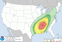
Last week's system never concerned me. This one does. This is a serious severe weather system with the potential for strong long track tornadoes across portions of MS, AL, southern Middle TN, and southern East TN. This is shaping up to be a deadly tornado outbreak across the south. I'd guess a likely SPC High Risk is coming for portions of MS/AL with tomorrow's Day 1 outlook.
Vol knight
Text a Buddy!
- Joined
- Oct 2, 2013
- Messages
- 9,023
- Likes
- 3,200
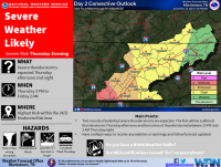
~Severe Weather Outbreak~
Something to keep in mind is that the severe weather threat tomorrow is conditional. There is still some uncertainty regarding the timing and amount of instability in East TN. There will be a period of moderate to heavy rain in the morning, which could lower the risk for severe thunderstorms later on if the Sun doesn't come out.
Timing:
First round (scattered cells) in the afternoon into the early evening hours. Second round (line) in the late evening/early overnight hours.
Hazards:
Damaging winds in excess of 60 mph is the main threat. A few tornadoes are also possible, especially south and west of Knoxville. A strong tornado (EF2-EF3) or 2 can't be ruled out. Also, there is a threat for flash flooding in the southern valley and plateau.
headhunter15
Well-Known Member
- Joined
- Mar 5, 2010
- Messages
- 9,203
- Likes
- 33,375
~Severe Weather Outbreak~
Something to keep in mind is that the severe weather threat tomorrow is conditional. There is still some uncertainty regarding the timing and amount of instability in East TN. There will be a period of moderate to heavy rain in the morning, which could lower the risk for severe thunderstorms later on if the Sun doesn't come out.
Timing:
First round (scattered cells) in the afternoon into the early evening hours. Second round (line) in the late evening/early overnight hours.
Hazards:
Damaging winds in excess of 60 mph is the main threat. A few tornadoes are also possible, especially south and west of Knoxville. A strong tornado (EF2-EF3) or 2 can't be ruled out. Also, there is a threat for flash flooding in the southern valley and plateau.
Hoping for heavy rain tomorrow morning to hopefully lessen the brunt. My brother and family are driving up tomorrow evening from SC and should arrive around midnight. I told him to watch the weather.
Vol knight
Text a Buddy!
- Joined
- Oct 2, 2013
- Messages
- 9,023
- Likes
- 3,200
MetVol
🌪️⚡❄️☀️🎣
- Joined
- Dec 8, 2020
- Messages
- 240
- Likes
- 708
Update:
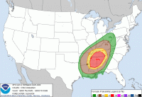
The enhanced risk has expanded eastward some to now include all areas along and west of interstate 75.
I don't say this lightly. People will die today. This is a setup for an extremely dangerous severe weather event with strong tornadoes. I haven't seen a setup this favorable for tornadoes around East TN in quite sometime. We'll see how much destabilization we get this afternoon, but it appears we're going to get it with some partial clearing and huge warm air advection. I'd bring the moderate risk closer to Knoxville if I were SPC.
Please have multiple ways to receive watches or warnings and have a plan for a safe place to seek shelter if warnings are issued.
headhunter15
Well-Known Member
- Joined
- Mar 5, 2010
- Messages
- 9,203
- Likes
- 33,375
I don't say this lightly. People will die today. This is a setup for an extremely dangerous severe weather event with strong tornadoes. I haven't seen a setup this favorable for tornadoes around East TN in quite sometime. We'll see how much destabilization we get this afternoon, but it appears we're going to get it with some partial clearing and huge warm air advection. I'd bring the moderate risk closer to Knoxville if I were SPC.
Please have multiple ways to receive watches or warnings and have a plan for a safe place to seek shelter if warnings are issued.
How close to April 27, 2011 do you think this will be?
MetVol
🌪️⚡❄️☀️🎣
- Joined
- Dec 8, 2020
- Messages
- 240
- Likes
- 708
I never like comparing events because each one is so different in their own way. That being said, today's atmosphere is very similar to the atmosphere on 4/27/11 across portions of the TN Valley. The spatial extent is slightly different, but the amount of instability and shear will result in likely large tornadoes across portions of MS/AL/TN.How close to April 27, 2011 do you think this will be?
Vol knight
Text a Buddy!
- Joined
- Oct 2, 2013
- Messages
- 9,023
- Likes
- 3,200
Matt2496
Well-Known Member
- Joined
- Dec 2, 2016
- Messages
- 14,471
- Likes
- 23,317
ArdentVol
need to escape the oates field
- Joined
- Dec 6, 2019
- Messages
- 9,798
- Likes
- 20,833
MetVol
🌪️⚡❄️☀️🎣
- Joined
- Dec 8, 2020
- Messages
- 240
- Likes
- 708
Overall hail threat isn't bad, but with any tornadic supercells, large hail will be likely. The strong rotating updrafts enhances the overall support for hail more than environmental instability would indicate. Same thing happened with the April 2011 event (didn't have any really impressive instability...no more than 1000 J/Kg).One difference that this system will have over the one in 2011 is that the hail threat won't be anywhere close as bad in East TN.


