volsarelife1
Well-Known Member
- Joined
- Jul 15, 2017
- Messages
- 14,299
- Likes
- 18,259
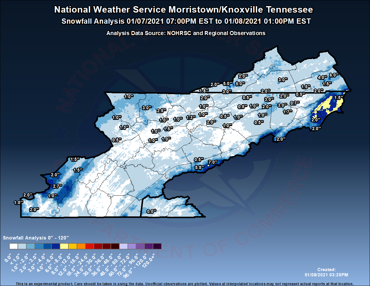
What’s funny is early on that’s what the TV folks and weather stations were indicating for the valley but I think the system appeared to come together a little better the last 48 hours so I’ll be curious to see what the weather gurus on here say happened. Some of the posters on here seem way more knowledgeable than your typical TV weather person so I’m curious to know what they say. To be fair I don’t know many TV weather people so my assumption could be incorrect. I’ve spent some time with Todd Howell mostly playing pick up ball with he and one of his sons. I will say he’s every bit as nice as he seems on TV but I tried to avoid bugging him about weather.Yeah was definitely a whiff on this one all around from the NWS to the local stations.
It’s wild. I know a few flakes did fall but I haven’t seen a single one. All this stuff is really fascinating and we have some pretty informed people on here though so I’m glad I found this thread.East Tennessee is the hardest area to forecast. WAA, Moisture & the setup of the heavier bands kept most of the valley from seeing anything. Usually, Models will all come into a agreement but they did not. MRX will never make anyone happy.
Yeah was definitely a whiff on this one all around from the NWS to the local stations.
Yeah this system was one of the most difficult and high uncertainty forecasts in several years. All depended upon a couple degrees either way and how much dynamic cooling occurred beneath the upper low. Wound up with nothing in many spots of the valley, but even some of the hills at about 1500-2000 ft elevation had 1-2" of snow in the valley. It was very elevation dependent. Compared to this system, the Christmas Eve snow was an easy forecast.To be fair to Morristown, they did stress even during the event that there was a huge amount of uncertainty with regards to snowfall amounts. Even last night, they were saying a degree or 2 could be the difference between the forecast busting high or low. Just because they put out advisories and warnings doesn't mean that they had a high degree of certainty with this system.
Yeah, I'm not really confident we'll see much impactful snow from this system as of now. It looked like there might be some phasing between the northern and southern shortwaves, but that doesn't appear as likely now. We'll see. Just won't be enough cold air or moisture without those shortwaves phasing and amplifying the longwave trough.Depending on the track, we will probably see a warm nose in the valley. GFS seems to have a pretty good handle on it
You speak some other language on here. Are you a meteorologist?Yeah, I'm not really confident we'll see much impactful snow from this system as of now. It looked like there might be some phasing between the northern and southern shortwaves, but that doesn't appear as likely now. We'll see. Just won't be enough cold air or moisture without those shortwaves phasing and amplifying the longwave trough.
Tricky topic because we'll often get lobes that break from the main circulation that venture into the lower 48. Probably the most recent memorable cold outbreak was in 2014 in this area when it got down to -1F in Knoxville. Nothing in recent memory like the -24F Knoxville temperature back in 1985. However, there's usually some impacts across portions of the US each winter season, and we have outbreaks of cold air each winter with low temperatures approaching single digits.David Aldrich was talking about the Polar Vortex paying much of the US a visit at the end of the month and first of Feb. if that happens, get ready for single digits and negative wind chills.
Anyone know when the last time the Polar Vortex split into East TN? Was it 2015, 2016?
Tricky topic because we'll often get lobes that break from the main circulation that venture into the lower 48. Probably the most recent memorable cold outbreak was in 2014 in this area when it got down to -1F in Knoxville. Nothing in recent memory like the -24F Knoxville temperature back in 1985. However, there's usually some impacts across portions of the US each winter season, and we have outbreaks of cold air each winter with low temperatures approaching single digits.
As I alluded to back in late December, early to mid January was looking colder than normal with the negative AO (which helps allow those polar intrusions of arctic air), negative NAO, and positive PNA patterns. The stratospheric warming event in late December also helped pave the way for the colder air across the Eastern US. The global circulations and teleconnections are continuing to show colder than normal air for the next 10-14 days.
After that point, there's indications that the pattern may begin to shift again with a more negative PNA pattern. If this happens, a warmer start to February would be expected across the Eastern US.
I'll be the first to acknowledge that my expertise isn't really seasonal forecasting, and there's a lot of sub-seasonal patterns that can add a lot of error to a seasonal or monthly forecast.
I’m with ya, this dude has been spot on. He talks way over my head but I trust him as far as the valley goes. It’s a hard region to predict but he has done wellCool. I didn’t know if this was just a hobby. I tell you what, you’ve been spot on with the things you’ve said from what I’ve seen. Impressive.
Dude you have been one of the heart and soul of this thread. It’s been one of my favorites on the board. I appreciate you guys all for your information and have learned from your input. Part of what makes this board so fun, vols mixed with all walks of lifeIt's good to see you posting on here, MetVol. I'm especially thankful for you posting, as I've been very busy recently and haven't been able to post too much of my thoughts on systems.
So what’s the consensus on tomorrow’s system? I’m assuming no impact to this area but is that correct? The NWS is expecting up to a half inch down in the Huntsville, AL area per my dad. Due to his job he gets regular updates there. Any shot at accumulation in Knoxville?
Cool. I didn’t know if this was just a hobby. I tell you what, you’ve been spot on with the things you’ve said from what I’ve seen. Impressive.
Glad to help where I can. Enjoy talking weather and the Vols. Years of local knowledge helps a forecast, but I can say that I've also been humbled many times. Just have to learn from the incorrect forecasts and move on.I’m with ya, this dude has been spot on. He talks way over my head but I trust him as far as the valley goes. It’s a hard region to predict but he has done well
Absolutely and well said. Looked like we might get the phasing about 5 days ago, but not going to happen. Probably quite a bit of mid-level clouds, virga, and maybe some light precip in spots on Monday (precip mainly across the higher elevations).Just another cold wet day. ULL tracks across the south have a hard time setting up moisture here adding in the WAA that it pushes though the valley won’t materialize. I was hoping to see the two pieces of energy intervene with one another but that doesn’t look to happen. Winter isn’t over here and I think we will have serval more shots at the white stuff before spring.
No one will ever be 100% correct, especially here, but you’re as knowledgeable as I’ve seen. Thanks for sharing what you know.Glad to help where I can. Enjoy talking weather and the Vols. Years of local knowledge helps a forecast, but I can say that I've also been humbled many times. Just have to learn from the incorrect forecasts and move on.