East Tennessee Weather

Status
Not open for further replies.
Significant Ice accumulation expected for Arkansas, West Tn., BH of Missouri, and Western Kentucky. Also parts of Middle Tn could see some accumulation of ice

Right now, its looking like at the least, 1/2 of ice if not more in isolated places

This could get nasty
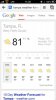
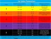
Thanks Count. I check in here daily to get your weather report.
 
Man, what I'd give to have some snow right now. It's currently in the 50's, but drizzling on and off.
 
Significant Ice accumulation expected for Arkansas, West Tn., BH of Missouri, and Western Kentucky. Also parts of Middle Tn could see some accumulation of ice

Right now, its looking like at the least, 1/2 of ice if not more in isolated places

This could get nasty

Grab some crash forms and tow slips and get your butt out of the office and hit the street. You know what's coming.
 
They are calling for some rough stuff here. In north west arkansas. (Fayetteville area)

Negative temps.

Now where I'm at (fort smith area) it's going to be 7 degrees. As far as accumulation I haven't heard a number yet. But 1/2 of ice wouldn't surprise me.


You guys be safe
 
  • Like
Reactions: 1 person
Agreed..I-240 is a nightmare when there is only 1/16 of a inch of snow on the ground. These retards get stupid here when they hear the word snow...Oh No's!!!!


.....no doubt.


After tomorrow, I'm taking the opportunity for a small sabbatical till monday.
 
Hey Count have you heard anything about the Lexington Tn area?

North of the I40 corridor will see more ice than south

The first storm will start Thursday as mostly rain and change over to freezing rain. That goes into Friday night early Saturday. Another storm rolls through Sunday. This storm may be worse

Reason is the cold air will be entrenched and most precipitation will be frozen

Depending on how deep the cold air is will determine what type we will have

Thick layer= Snow
Thin layer at the surface= Freezing Rain

Expect widespread power outages, hazardous roads, and basic pandemonium. West Tn people dont handle winter weather very good
 
Last edited:
Grab some crash forms and tow slips and get your butt out of the office and hit the street. You know what's coming.

If its bad, we will likely not respond to any accidents that are not either a serious injury or there needs to be traffic control.

I've worked my share, especially on the overpasses when they slick up

It will be heading up towards your way, so you guys stay safe out there
 
Thanks Count and our right most people here are idiots when it comes to winter weather
 
North of the I40 corridor will see more ice than south

The first storm will start Thursday as mostly rain and change over to freezing rain. That goes into Friday night early Saturday. Another storm rolls through Sunday. This storm may be worse

Reason is the cold air will be entrenched and most precipitation will be frozen

Depending on how deep the cold air is will determine what type we will have

Thick layer= Snow
Thin layer at the surface= Freezing Rain

Expect widespread power outages, hazardous roads, and basic pandemonium. West Tn people dont handle winter weather very good

You really think its going to be that bad? Most times when the news talks up serve weather it never happens, perhaps I'm being too skeptical though. Here in Brighton its still 55 something degrees.
 
You really think its going to be that bad? Most times when the news talks up serve weather it never happens, perhaps I'm being too skeptical though. Here in Brighton its still 55 something degrees.

Yes

There is a blast of cold artic air that is coming

Low's Friday night will be in the 10's and probably single digit wind chills
 
Yes

There is a blast of cold artic air that is coming

Low's Friday night will be in the 10's and probably single digit wind chills

Thanks man. I just don't see it, Intellicast has the temps for Thursday through Sunday as 55, 35, 33, and 33 for Brighton. I just don't how its going to get any colder heck today is 73 outside. Just don't see how the ground will be cold enough to freeze over.
 
Middle TN is supposed to get ice and sleet this weekend, hopefully it stays there and away from Knoxville.
 
Ice Storm Warning

High probability of Ice accumulation over 1" from Little Rock into Memphis and up to Paris

This not gonna be good
 
Last edited:
Ice Storm Warning

High probability if Ice accumulation over 1" from Little Rock into Memphis and up to Paris

This not gonna be good

I just spent $250 on a kerosene heater and kerosene because of your updates!
I'm just east of Memphis in Oakland.
 
Last edited:
What should I be expecting here in Brighton/Tipton County?

The ice impact index released by NOAA this morning takes into account wind, amount of ice and determines impact to local utilities

Your area is in the 5 range or catastrophic range. Meaning sustained power outages could last weeks

We are in the 4 range. We will likely be without power for up to two weeks
 

Attachments

  • UtilityIceIndexParameters.jpg
    UtilityIceIndexParameters.jpg
    82.4 KB · Views: 8
Last edited:
Status
Not open for further replies.
Advertisement


Back
Top