rocktopper16
Spread sunshine, Not shade.
- Joined
- Jan 8, 2012
- Messages
- 12,019
- Likes
- 12,056
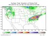
Not sure how after all the meteorologist have been talking about it but people could get caught way off guard with this storm.
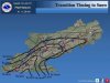
It's not even raining at the moment but the backside wrap is going to be the snowmaker for us. If you look at the radar the bulk of the moisture is west of us and the road conditions are deteriorating as it moves East.