Good Afternoon Folks!
Today was pretty but don't put those winter clothes away just yet.
This weekend will be a chilly one, Not expecting any major issues but a few flakes may fly around Saturday morning but that's not my concern.
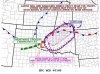
Thursday (Tomorrow) will be our first shot at severe weather. I know many meteorologist are down playing how light the storms will be as I thought they would be as well but the front and upper level low is picking up strength. Today, The plains had a slight risk of severe weather now it's high. I expect it to be moderate here tomorrow. Strong straight line winds will bring down trees that have suffered from the Ice storm and possiby some hail will be mixed in. Stay tuned tomorrow.
TORCON 3/10