rocktopper16
Spread sunshine, Not shade.
- Joined
- Jan 8, 2012
- Messages
- 12,193
- Likes
- 12,489
Is this going to be a "training" type of rain? It looks like some of the models are keeping the line of storms parked right over east TN. I may be looking at it wrong though.
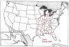
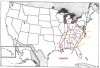
Alert:
New Tornado watch for folks in and around Memphis until 8:00 PM CST. There is a PDS attached to this watch. If you're in this watch area, I highly recommend getting your closet or basement ready now before the storms hit.
For those who don't know what a PDS is, it stands for Particularly Dangerous Situation. It's only added to areas that have an extremely high risk for tornadoes and some intense tornadoes.