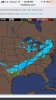
Issuing Office: Knoxville/Tri-Cities
Source: National.Weather.Service
3:21am EST, Tue Jan 16
... WINTER WEATHER ADVISORY NOW IN EFFECT FROM NOON TODAY TO 1 AM EST WEDNESDAY... * WHAT... SNOW IS EXPECTED. PLAN ON SLIPPERY ROAD CONDITIONS, INCLUDING DURING THE EVENING COMMUTE. TOTAL SNOW ACCUMULATIONS OF 1 TO 3 INCHES ARE EXPECTED. * WHERE... PORTIONS OF EAST TENNESSEE, SOUTHWEST VIRGINIA AND SOUTHWEST NORTH CAROLINA. * WHEN... FROM NOON TODAY TO 1 AM EST WEDNESDAY. * ADDITIONAL DETAILS... BE PREPARED FOR REDUCED VISIBILITIES AT TIMES. PRECAUTIONARY/PREPAREDNESS ACTIONS... A WINTER WEATHER ADVISORY FOR SNOW MEANS PERIODS OF SNOW WILL CAUSE PRIMARILY TRAVEL DIFFICULTIES. BE PREPARED FOR SNOW COVERED ROADS AND LIMITED VISIBILITIES, AND USE CAUTION WHILE DRIVING. THE LATEST ROAD CONDITIONS FOR THE STATE YOU ARE CALLING FROM CAN BE OBTAINED BY CALLING 5 1 1.
More Information
... LIGHT SNOW ACCUMULATIONS EXPECTED TODAY INTO EARLY TONIGHT... .A STRONG COLD FRONT WILL BRING COLDER AIR AND SNOW TO THE SOUTHERN APPALACHIAN REGION. AN AREA OF LIGHT SNOW WILL MOVE ACROSS THE AREA TODAY AND EARLY TONIGHT, WITH SOME LIGHT SNOW ACCUMULATIONS EXPECTED.
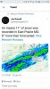
NWS pushed it to start at 12 noon now instead of what they originally had as 10am. What do you think RT or VK?
Yeah, I'm afraid I've seen this story before. It gets pushed back later and later until all we get is a half inch.