East Tennessee Weather II

So whatcha thinking for West Knoxville with this storm? As much as I hated it, you were spot on last time.

My thought is for not much. Could get some light amounts of an inch or so, but more than likely, close to nothing. Just really hard to get accumulations in the valley and foothills with that southeast flow. Warms it up way too much. Need the surface high more across the Ohio Valley with NE flow ahead of the precipitation for the big valley snows.

Also, a big reason that areas just south of Chattanooga are in a watch is because their criteria is different at FFC. Makes a weird hole across most of the East TN valley.
 
  • Like
Reactions: hUTch2002
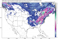
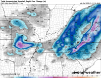
Models are still all over the place with this one. It's ridiculous. At this point you just shoot for the middle. Toss out the outliers like the GFS (showing a pretty solid snow for a lot of the valley) and the HRRR (showing zilch for all the valley and even zilch for half of the Cumberland plateau) and find the middle ground like the ECMWF showing light snowfall accumulations for the most part. I don't buy the NAM either. Too far west. Maybe they will get their act together, but we'll see. Gotta go with the ECMWF for now. It shows what I have typically seen in events like this.
 
  • Like
Reactions: headhunter15
I want to point out a few points that I think might be getting overlooked to some degree. This system is going to result in a messy precip type forecast across the valley. That's just what happens with this kind of system because of the SE flow.

What that means is that a lot of areas in East Tennessee are going to see rain, sleet, snow, maybe some freezing rain, and snow again. It's going to switch back and forth. That's why it's not just what model you look at for snow, it's also what model snow parameters you look at.

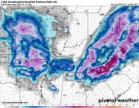
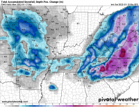
For example, the GFS shows decent snow accumulation across the entire area, but when you account for melting and compaction from temperatures above freezing and mixing in with rain and sleet, the totals are quite a bit lower.

1642252084507.png
1642252099853.png

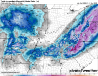
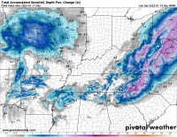
The same can be shown at a more high resolution on the HRRR. Model snowfall shows good accumulation but actual depth with sleet and rain mixing in will be lower.

1642252199170.png
1642252218102.png

It's going to be a messy Sunday with lots of precip types with temperatures in the 30s. May get some very different snowfall observations based on the source too. FAA observers at airports take observations every 6 hours and clear the snowboard while COOP in NWS takes observations once a day or at the greatest point (snowboard is only cleared once though).
 
It’s funny. If you look at Weatherbug it shows little or no accumulation for Knoxville but for Oak Ridge it says up to 6 inches. When you look at the hourly forecast they look the same though with mixed precipitation turning to all rain and then back to mixed. It’s also above freezing for both places the entire time. That Oak Ridge prediction must be a mistake. If it never changes to rain in the middle then maybe it’s possible but not if it becomes all rain at any point.
 
It’s funny. If you look at Weatherbug it shows little or no accumulation for Knoxville but for Oak Ridge it says up to 6 inches. When you look at the hourly forecast they look the same though with mixed precipitation turning to all rain and then back to mixed. It’s also above freezing for both places the entire time. That Oak Ridge prediction must be a mistake. If it never changes to rain in the middle then maybe it’s possible but not if it becomes all rain at any point.

I'm not familiar with their system, but my guess is that their Oak Ridge point is pulling in data for the higher elevations around Windrock/Buffalo MTN where it's about 2500 ft elevation.

I also think areas like Chattanooga will probably see about nothing, but places like Lookout or Signal Mountain could see a couple inches of snow and icy slush before it's all over on Sunday.
 
I always just assumed weatherbug (and most weather apps similar to it) were just automated forecasts with little to no human input anyway.
 
  • Like
Reactions: MetVol
Latest NAM run bringing more snowView attachment 428433
Just be leery of some of those outputs. That's including sleet with snow at a 10:1 ratio which is going to way overinflate totals. Could see some snow in the valley after changeover, but going to be tough to get meaningful accumulation.

Same model run, but accounting for some more of the sleet and rain mix plus melting.

1642269830583.png
 
Would not be surprised to see the winter storm warning in the mountains to be upgraded to a blizzard warning, with the mountains having a high wind watch in effect for tomorrow.
 
I want to point out a few points that I think might be getting overlooked to some degree. This system is going to result in a messy precip type forecast across the valley. That's just what happens with this kind of system because of the SE flow.

What that means is that a lot of areas in East Tennessee are going to see rain, sleet, snow, maybe some freezing rain, and snow again. It's going to switch back and forth. That's why it's not just what model you look at for snow, it's also what model snow parameters you look at.

For example, the GFS shows decent snow accumulation across the entire area, but when you account for melting and compaction from temperatures above freezing and mixing in with rain and sleet, the totals are quite a bit lower.

View attachment 428384
View attachment 428385

The same can be shown at a more high resolution on the HRRR. Model snowfall shows good accumulation but actual depth with sleet and rain mixing in will be lower.

View attachment 428386
View attachment 428387

It's going to be a messy Sunday with lots of precip types with temperatures in the 30s. May get some very different snowfall observations based on the source too. FAA observers at airports take observations every 6 hours and clear the snowboard while COOP in NWS takes observations once a day or at the greatest point (snowboard is only cleared once though).

Good stuff!

I was speaking with my meteorologist friend today and he and I are of the belief that there could be surprises here and there all across the country with this system. So many variables.
 
  • Like
Reactions: MetVol
Interesting. Winter Storm Warning now for Anderson County and a WWA for Knox.

Sounds reasonable. Higher elevations of Anderson will get some decent snow and upslope cooling in SE flow. Minor accumulation around Knoxville probably at least warrants an advisory.

MRX actually mentioned this in one of their discussions.

Yeah wouldn't be surprised if it's upgraded. Sometimes gets mention in the additional details section of the WSW if conditions will be present across the higher terrain, too.
 
It’s interesting. I’m seeing predictions on Weatherbug that are increasing totals. Kingston was showing nothing until all of sudden this evening now it says up to 5 inches. Oak Ridge has now been moved up to 8. Knoxville is up to 2 at the moment.
 

VN Store


Back
Top