Just updated....
926 PM EST Mon Jan 28 2019 /826 PM CST Mon Jan 28 2019/
This Hazardous Weather Outlook is for portions of Southwest North
Carolina, East Tennessee and Southwest Virginia.
.DAY ONE, Tonight
An arctic cold front will move into the forecast area late
tonight. Widespread rain will develop around midnight tonight,
then rapidly change over to snow during the pre - dawn hours
Tuesday morning as the arctic front moves through.
For the plateau, and even some parts of the southern and western
Tennessee Valley, some light snow accumulation of around an inch
or less is expected before daybreak on Tuesday.
.DAYS TWO THROUGH SEVEN, Tuesday through Sunday
The arctic cold front will have moved into the mountains by
daybreak Tuesday morning, with temperatures falling well below
freezing behind it. However, precipitation will continue during
the morning hours, likely as all snow. While additional snowfall
over the plateau region will be light during the day Tuesday, much
of the valley and mountainous areas will see their greatest
snowfall during the morning hours Tuesday. Total snow
accumulations of up to 2 inches, with locally higher amounts up
to 3 inches possible especially in higher elevations areas, will
be common across east Tennessee, southwest Virginia, and southwest
North Carolina, but 3 to 5 inches is expected across the higher
elevations of the Smoky Mountains. Snow and ice covered roadways
are expected to cause travel problems.
Dangerously cold wind chill values of -5 to -15 degrees are expected
Tuesday night through Thursday morning across parts of southwest
Virginia, northeast Tennessee, and the Smoky Mountains.
An upper level disturbance will bring light snow to northeast
Tennessee and southwest Virginia Wednesday. Light accumulations of a
trace to half of an inch are possible which could result in slippery
roads.
Another system could bring a mix of rain and snow to most of the
region Friday morning.


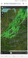
 here whether it's a bust or not. Lol