volwindy
sunshine hiker
- Joined
- Sep 6, 2005
- Messages
- 92,769
- Likes
- 37,048
Where’s that? Can’t be Knoxville.
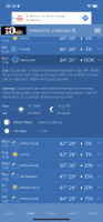
The NWS blend of models is showing 1 to 3 inches for all of East Tennessee. The Euro is quite aggressive, showing 4 to 8 inches area wide for the 10:1 ratio over 24 hours, the GFS takes the low further north giving us mainly a cold rain. Time will tell how these models shake out.
Mine was for Asheville.
We have pretty useless forecasts here, other than one local guy. NWS is down in Greenville/ Spartanburg, and forecasts for WNC are all over the place.
If you like snow then Knoxville is about the worst non-coastal place to live.One model run from David Aldrich
View attachment 427904
Will be such a travesty if Memphis to the plateau get snow and the valley gets the shaft.