East Tennessee Weather II

Chatting with a friend of mine who is also a weather enthusiast and lives in Campbell county. He told me that he wouldn't be surprised if Morristown drags their feet with the advisories and warnings and doesnt issue any until snow is on the ground. Do you guys remember earlier this week we had a period of light snow showers and flurries move through parts of East TN? I actually ended up getting a little over 1 inch of snow near La Follette when I was only expected to get a light dusting. Jamestown got around 3 inches of snow. Both Campbell and Fentress counties didnt have a single winter weather advisory despite that.
I think this will bring more snow to the area than they are expecting.
 
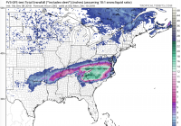
The Canadian Model shows that the warm air aloft will be more westward, therefore allowing more snowfall in the valley.

The GFS-FV3 model shows the warm air well south only jutting out as far as Chattanooga.

The GFS model shows the warm air covering the valley entirely with little to no snowfall in the valley.
You're free to continue using the global models, but they are pretty much pointless to use this close to the event. I'll mainly be focusing on the short range models like the NAM, 3k Hi resolution NAM, RGEM, HRRR, SREF, ect.
 
I need some clarification. I’m looking at the NAM 12k on Pivotal weather. What is the difference in the TOTAL ACCUMULATED SNOWFALL and SNOW DEPTH maps? Maybe a stupid question.
 
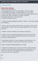
Here is the Winter Storm Warning and Winter Weather Advisory information for the Northern Plateau and Central Valley:

...WINTER WEATHER ADVISORY IN EFFECT FROM 1 AM SUNDAY TO NOON EST MONDAY...

* WHAT...Rain this evening will change to moderate to heavy snow early Sunday morning. Total snow accumulations of 2 to 5 inches expected.
* WHERE...Central Tennessee Valley and parts of the Northern Plateau.
* WHEN...Rain this evening changing to snow from 3 and 6 AM Sunday morning, and then tapering to drizzle or flurries by early afternoon.
* ADDITIONAL DETAILS...Plan on slippery road conditions. The hazardous conditions could impact the morning commute.

...WINTER STORM WARNING IN EFFECT FROM 11 PM THIS EVENING TO NOON EST MONDAY...
* WHAT...Rain this evening will change to moderate to heavy snow early Sunday morning. Total snow accumulations of 2 to 7 inches expected.
* WHERE...Northern Plateau and northeast Tennessee.
* WHEN...Rain this evening changing to snow from 3 and 6 AM Sunday morning, and then tapering to drizzle or flurries by late morning or early afternoon.
* ADDITIONAL DETAILS...Plan on slippery road conditions. The hazardous conditions could impact the morning commute.
 
I’m not sure which of these to believe, but they both look nice.
 

Attachments

  • ACAA4757-42C8-4530-96DC-7E92827BC08F.png
    ACAA4757-42C8-4530-96DC-7E92827BC08F.png
    593 KB · Views: 20
  • AF9736FA-BFFE-40D9-A5E4-DFA8024BF89D.png
    AF9736FA-BFFE-40D9-A5E4-DFA8024BF89D.png
    459 KB · Views: 19
I am so confused..the WC app is still downplaying the hell out of this for where I live here in Harlan county.. However the NWS has us under a pretty bad warning 🤔
 

VN Store


Back
Top